


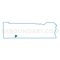
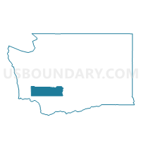
Drews Prairie Voting District, Lewis County, Washington
About
Outline

Summary
| Unique Area Identifier | 687485 |
| Name | Drews Prairie Voting District |
| County | Lewis County |
| State | Washington |
| Area (square miles) | 10.36 |
| Land Area (square miles) | 10.14 |
| Water Area (square miles) | 0.22 |
| % of Land Area | 97.92 |
| % of Water Area | 2.08 |
| Latitude of the Internal Point | 46.43300260 |
| Longtitude of the Internal Point | -122.90144850 |
Maps

Graphs
Select a template below for downloading or customizing gragh for Drews Prairie Voting District, Lewis County, Washington


Neighbors
Neighoring Voting District (by Name) Neighboring Voting District on the Map
- Cowlitz Voting District, Lewis County, WA
- Salmon Creek Voting District, Lewis County, WA
- Stillwater Voting District, Lewis County, WA
- Toledo Voting District, Lewis County, WA
- Veness Voting District, Lewis County, WA
Top 10 Neighboring County Subdivision (by Population) Neighboring County Subdivision on the Map
Top 10 Neighboring Place (by Population) Neighboring Place on the Map
Top 10 Neighboring Unified School District (by Population) Neighboring Unified School District on the Map
- Castle Rock School District, WA (9,891)
- Winlock School District, WA (4,446)
- Toledo School District, WA (4,387)